Maps: Difference between revisions
m (→South-East Island and South-West Island: Anyone have any south island maps?) |
m (→South-East Island and South-West Island: wups... bad markup) |
||
| Line 45: | Line 45: | ||
==[[South-East Island]] and [[South-West Island]]== | ==[[South-East Island]] and [[South-West Island]]== | ||
The islands have been sunk into the sea, but the maps remain. | The islands have been sunk into the sea, but the maps remain.<br> | ||
<s>* [http://battlemaster.org/maps-5/SouthIsland-Large-Details.jpg '''Full Map'''] - Full-size map with region names and borders. (1.5 MB) | <s> | ||
* [http://battlemaster.org/maps-5/SouthIsland-Large-Details.jpg '''Full Map'''] - Full-size map with region names and borders. (1.5 MB) | |||
* [http://battlemaster.org/maps-5/SouthIsland-Large-Geo.jpg '''Geographical Map'''] - Full-size map, geography only. (1.4 MB) | * [http://battlemaster.org/maps-5/SouthIsland-Large-Geo.jpg '''Geographical Map'''] - Full-size map, geography only. (1.4 MB) | ||
* [http://battlemaster.org/maps-5/SouthIsland-Details.jpg '''Small Map'''] - Smaller map with region names and borders. (327 KB) | * [http://battlemaster.org/maps-5/SouthIsland-Details.jpg '''Small Map'''] - Smaller map with region names and borders. (327 KB) | ||
| Line 53: | Line 54: | ||
*[http://battlemaster.org/maps-5/WorldMap-Current.jpg '''Last Political Map'''] - Map showing the last political map of SWI. (113 KB)</s> | *[http://battlemaster.org/maps-5/WorldMap-Current.jpg '''Last Political Map'''] - Map showing the last political map of SWI. (113 KB)</s> | ||
''The above links were broken when the servers crashed.'' | ''The above links were broken when the servers crashed.'' | ||
* [[File:SouthernIslandsRegions.png]] - Small map, with region names and borders. '''If you have a big map, or the geographical map, please post it!''' | * [[:File:SouthernIslandsRegions.png]] - Small map, with region names and borders. '''If you have a big map, or the geographical map, please post it!''' | ||
==[[SpellMaster]] Era== | ==[[SpellMaster]] Era== | ||
Revision as of 12:35, 21 October 2010
Here are the maps of the BattleMaster continents. Please download these images through right-click instead of repeatedly viewing them, because some of them are large and cause unnecessary traffic.
Atamara
- Full Map - Full-size map with region names and borders. (1.5 MB)
- Geographical Map - Full-size map, geography only. (1.4 MB)
- Small Map - Smaller map with region names and borders. (327 KB)
- Small Geo Map - Smaller geographic map. (301 KB)
- Current Political Map - Map showing the current political map. (357 KB)
Beluaterra
- Full Map - Full-size map with region names and borders. (1.5 MB)
- Geographical Map - (same as for Atamara above)
- Small Map - Smaller map with region names and borders. (327 KB)
- Small Geo Map - (same as for Atamara above)
- Current Political Map - Map showing the current political map. (354 KB)
Colonies
- Full Map - Full-size map with region names. (1.6 MB)
- Geographical Map - Full-size map, geography only. (1.6 MB)
- Small Map - Smaller map with region names. (341 KB)
- Small Geo Map - Smaller geographic map. (332 KB)
- Current Political Map - Map showing the current political map. (351 KB)
Dwilight
- Full Map - Full-size map with region names and borders. (1.6 MB)
- Small Map - Smaller map with region names and borders. (368 KB)
- Current Political Map - Map showing the current political map. (379 KB)
- Historical maps. These are the original working layouts, and do not reflect the final geography of the island.
- Geographical Map (Original Ver.) - Full-size map, geography only. (1.6 MB)
- Small Geo Map (Original Ver.) - Smaller geographic map. (311 KB)
- Miscellaneous maps used during the construction of the island and it's databases.
- Region ID Map - Full-size map showing the ID number for each region. (1.6 MB)
- Weather Area Map - Small-size map showing boundaries between weather areas. (704 KB)
East Continent and Far East
- Full Map - Full-size map before the Bad Tidings with region names and borders. (1.3 MB)
- Geographical Map - Full-size map before the Bad Tidings, geography only. (1.3 MB)
- Full Map - Full-size map with region names and borders. (1.3 MB)
- Geographical Map - Full-size map, geography only. (1.3 MB)
- Small Map - Smaller map with region names and borders. (292 KB)
- Small Geo Map - Smaller geographic map. (272 KB)
- Current Political Map - Map showing the current political map of East Continent. (358 KB)
- Current Political Map - Map showing the current political map of the Far East Island. (365 KB)
-Large-Details.jpg)
-Large-Geo.jpg)
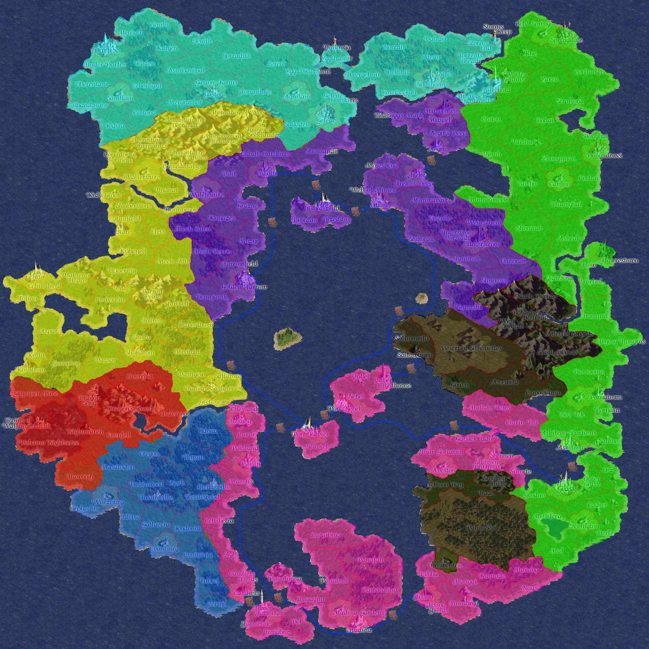
South-East Island and South-West Island
The islands have been sunk into the sea, but the maps remain.
- Full Map - Full-size map with region names and borders. (1.5 MB)
- Geographical Map - Full-size map, geography only. (1.4 MB)
- Small Map - Smaller map with region names and borders. (327 KB)
- Small Geo Map - Smaller geographic map. (301 KB)
- Last Political Map - Map showing the last political map of SEI. (111 KB)
Last Political Map - Map showing the last political map of SWI. (113 KB)
The above links were broken when the servers crashed.
- File:SouthernIslandsRegions.png - Small map, with region names and borders. If you have a big map, or the geographical map, please post it!
SpellMaster Era
- Full Map - Full-size map with region names. (1.2 MB)