Difference between revisions of "Maps"
Medron Pryde (talk | contribs) |
(Updated the Atamara maps.) |
||
| Line 1: | Line 1: | ||
| − | + | Here are the maps of the BattleMaster continents. Please download these images, if it is listed as jpg, through right-click instead of repeatedly viewing them, because some of them are large and cause unnecessary traffic. | |
| − | Here are the maps of the BattleMaster continents. Please download these images through right-click instead of repeatedly viewing them, because some of them are large and cause unnecessary traffic. | ||
Political maps are included for posterity, but are no longer updated since the introduction of a new political map system in mid-2012. | Political maps are included for posterity, but are no longer updated since the introduction of a new political map system in mid-2012. | ||
| − | ==[[Atamara]] | + | == Atamara == |
| − | * [http://battlemaster.org/ | + | ''For the island, visit: [[Atamara]].'' |
| − | * [http://battlemaster.org/ | + | |
| − | * [http://battlemaster.org | + | * [http://maps.battlemaster.org/AtamaraWarm/openlayers.html '''Full Map (Warm)'''] - Full-size map with region names and borders. (HTML) |
| − | * [http://battlemaster.org/maps | + | * [http://maps.battlemaster.org/AtamaraGeoWarm/openlayers.html '''Geographical Map (Warm)'''] - Full-size map, geography only (HTML) |
| − | * [http://battlemaster.org/ | + | * [http://maps.battlemaster.org/Atamara/openlayers.html '''Full Map (Cold)'''] - Full-size map with region names and borders during the ice event. (HTML) |
| + | ** [http://maps.battlemaster.org/Atamara.jpg '''Full Map (Cold - JPG)'''] - Full-size map with region names and borders. (JPG, 3.1 MB) | ||
| + | * [http://maps.battlemaster.org/AtamaraGeo/openlayers.html '''Geographical Map (Cold)'''] - Full-size map, geography only. (HTML) | ||
| + | ** [http://maps.battlemaster.org/AtamaraGeo.jpg '''Geographical Map (Cold - JPG)'''] - Full-size map, geography only. (JPG, 3 MB) | ||
| + | |||
| + | === History === | ||
| + | |||
| + | * [http://maps.battlemaster.org/History-2/ '''Historical Maps of Atamara'''] - A directory of maps with the realms for each day from 2012-08-21 to 2016-02-27. (DIR) | ||
| + | * [http://youtu.be/HNNfDDcdGXc '''Atamara Time-lapse from 2005 to 2012'''] - A video showing the progression of the realms on Atamara from 2005 to 2012. | ||
==[[Beluaterra]]== | ==[[Beluaterra]]== | ||
Revision as of 20:40, 11 March 2019
Here are the maps of the BattleMaster continents. Please download these images, if it is listed as jpg, through right-click instead of repeatedly viewing them, because some of them are large and cause unnecessary traffic.
Political maps are included for posterity, but are no longer updated since the introduction of a new political map system in mid-2012.
Contents
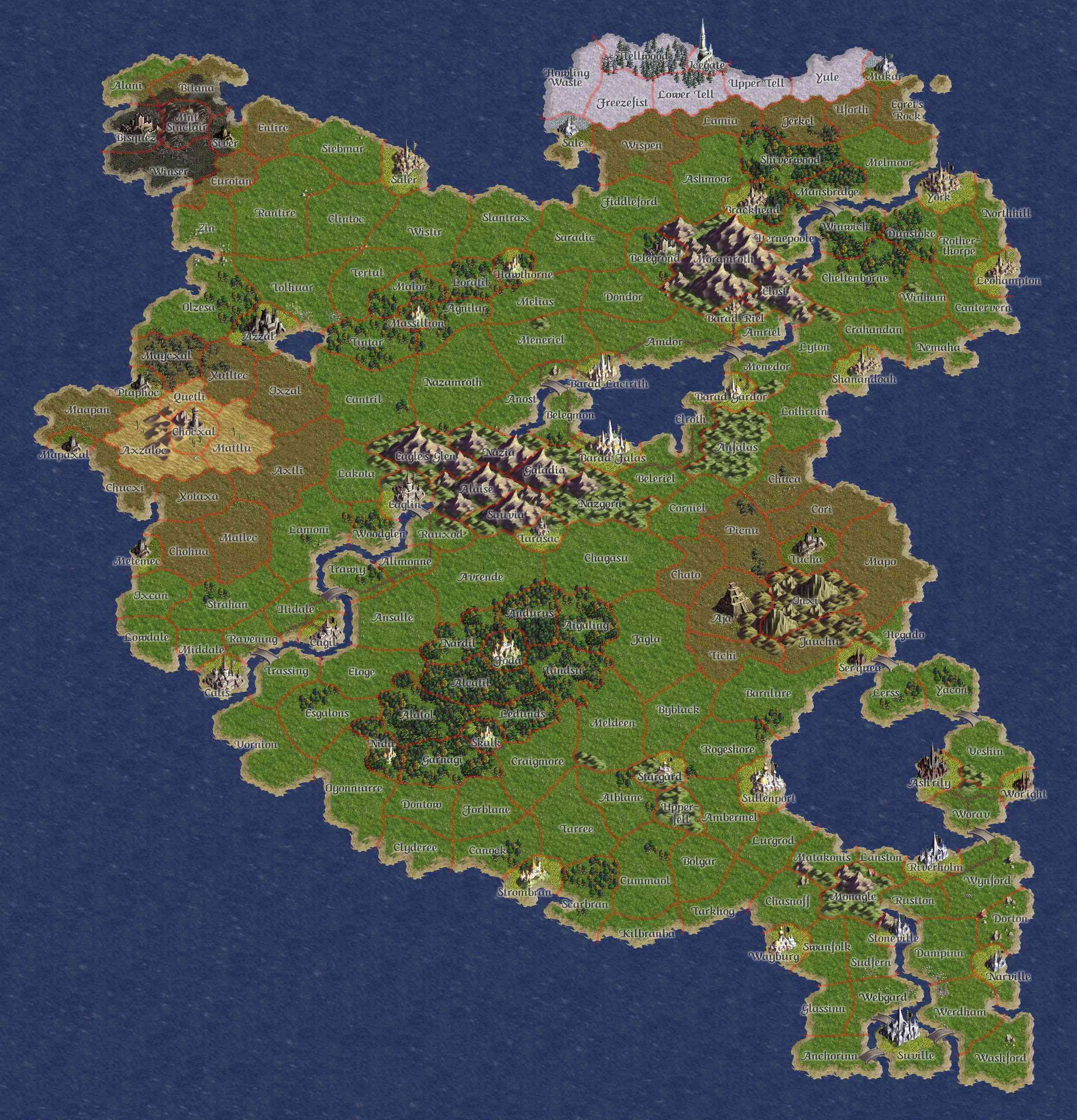
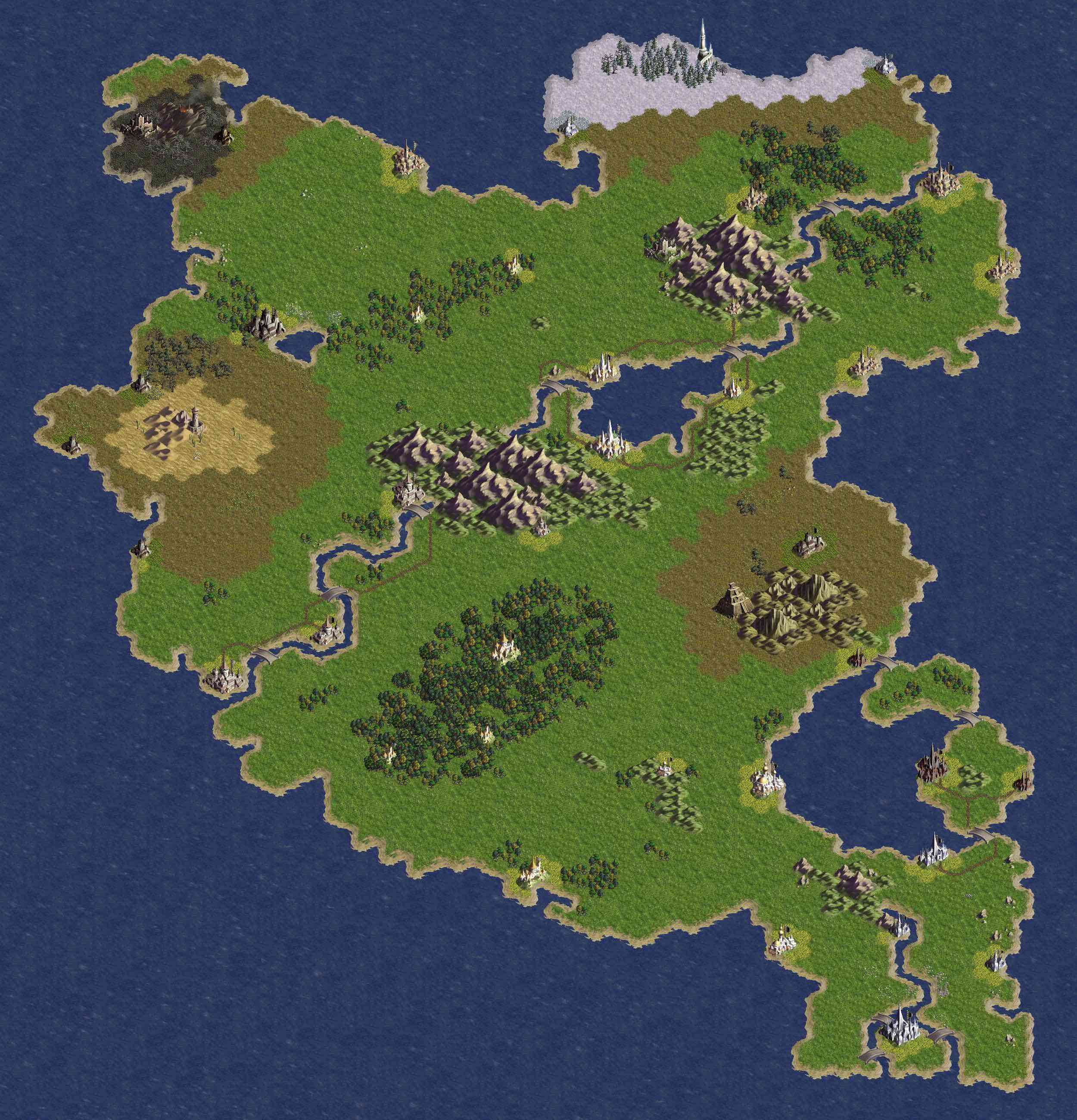
Atamara
For the island, visit: Atamara.
- Full Map (Warm) - Full-size map with region names and borders. (HTML)
- Geographical Map (Warm) - Full-size map, geography only (HTML)
- Full Map (Cold) - Full-size map with region names and borders during the ice event. (HTML)
- Full Map (Cold - JPG) - Full-size map with region names and borders. (JPG, 3.1 MB)
- Geographical Map (Cold) - Full-size map, geography only. (HTML)
- Geographical Map (Cold - JPG) - Full-size map, geography only. (JPG, 3 MB)
History
- Historical Maps of Atamara - A directory of maps with the realms for each day from 2012-08-21 to 2016-02-27. (DIR)
- Atamara Time-lapse from 2005 to 2012 - A video showing the progression of the realms on Atamara from 2005 to 2012.
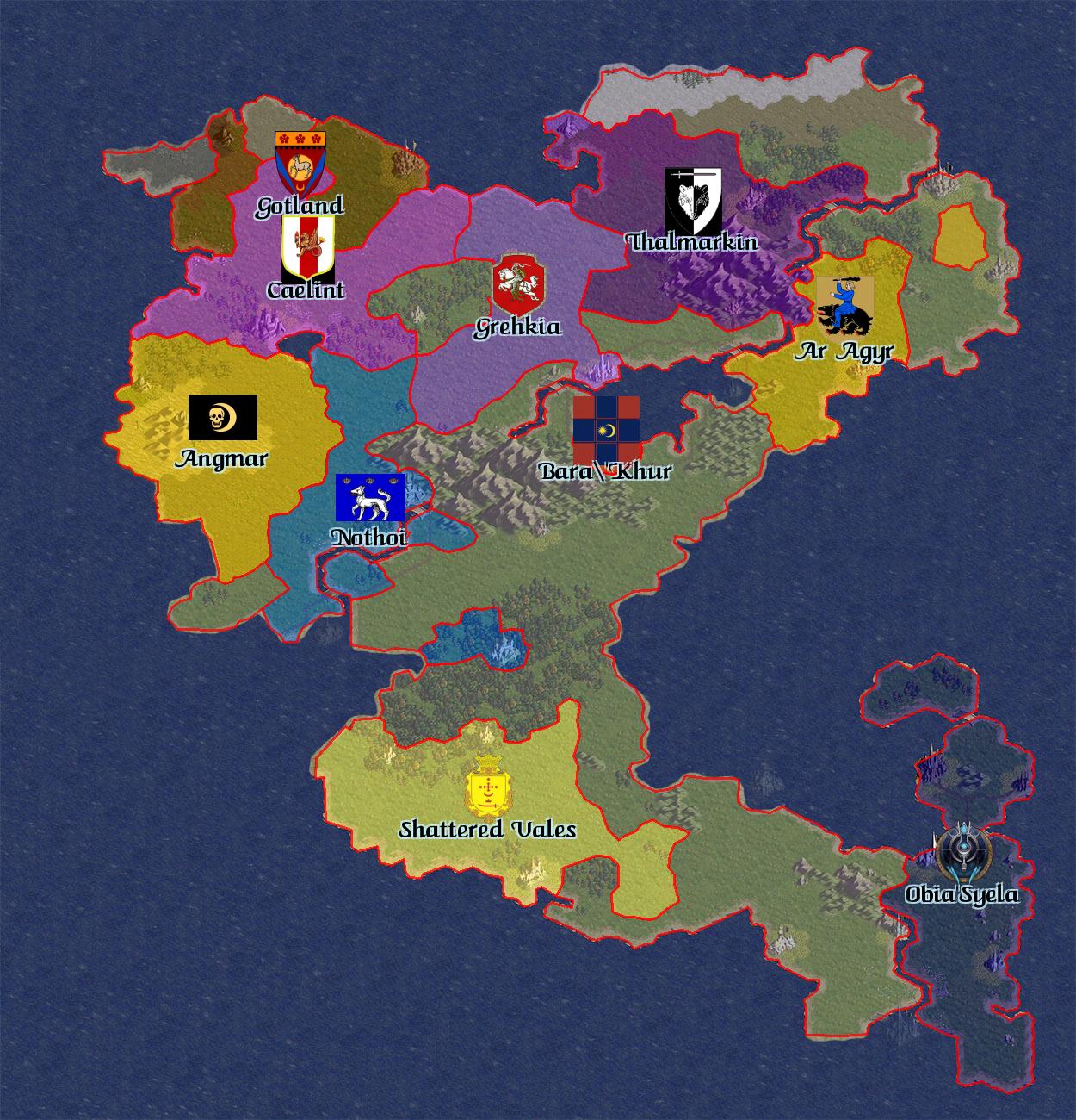
Beluaterra
These maps represent Beluaterra as she was before the Fourth and Fifth Invasions, when her borders were drastically altered in the fight against the inhuman factions. For the map before the blight, look here.
Working links to wiki files
- Original Beluaterra - Large Base Map with region names of the original Beluaterra in 2003.
- Blighted Beluaterra - Political Map with region names and borders of Blighted Beluaterra in 2011.
- Post Fifth Invasion Beluaterra - Large Map with region names of Post Fifty Invasion Beluaterra in July 2012.
- Sixth Invasion Beluaterra - Small GIF showing the Sixth Invasion's progress from August 2015 to August 2017.
- Post Seventh Invasion Beluaterra - Dynamic Map showing Post Seventh Invasion Beluaterra in January 2019.
- Post Seventh Invasion Beluaterra - Political Map showing Post Seventh Invasion Beluaterra in March 2019.
Non-working Links to game maps.
- Full Map - Full-size map with region names and borders. (1.5 MB)
- Geographical Map - (same as for Atamara above)
- Small Map - Smaller map with region names and borders. (327 KB)
- Small Geo Map - (same as for Atamara above)
- Political Map - Last recorded political map. (354 KB)
Colonies
- Full Map - Full-size map with region names. (1.6 MB)
- Geographical Map - Full-size map, geography only. (1.6 MB)
- Small Map - Smaller map with region names. (341 KB)
- Small Geo Map - Smaller geographic map. (332 KB)
- Political Map - Last recorded political map. (351 KB)
Dwilight
- Full Map - Full-size map with region names and borders. (1.6 MB)
- Small Map - Smaller map with region names and borders. (368 KB)
- Political Map - Last recorded political map. (379 KB)
- Historical maps. These are the original working layouts, and do not reflect the final geography of the island.
- Geographical Map (Original Ver.) - Full-size map, geography only. (1.6 MB)
- Small Geo Map (Original Ver.) - Smaller geographic map. (311 KB)
- Miscellaneous maps used during the construction of the island and it's databases.
- Region ID Map - Full-size map showing the ID number for each region. (1.6 MB)
- Weather Area Map - Small-size map showing boundaries between weather areas. (704 KB)
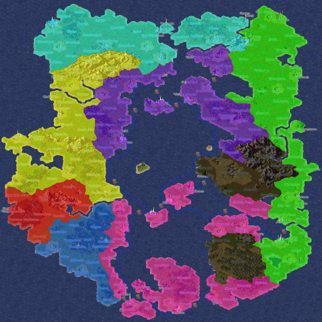
East Continent and Far East
- Full Map - Full-size map before the Bad Tidings with region names and borders. (1.3 MB)
- Geographical Map - Full-size map before the Bad Tidings, geography only. (1.3 MB)
- Full Map - Full-size map with region names and borders. (1.3 MB)
- Geographical Map - Full-size map, geography only. (1.3 MB)
- Small Map - Smaller map with region names and borders. (292 KB)
- Small Geo Map - Smaller geographic map. (272 KB)
- Political Map - Last recorded political map of East Continent. (358 KB)
- Political Map - Last recorded political map of the Far East Island. (365 KB)
-Large-Details.jpg)
-Large-Geo.jpg)
South-East Island and South-West Island
The islands have been sunk into the sea, but the maps remain and have since been utilised in BattleMaster:War Islands.
- Small Map - Smaller map with region names and borders. (941 KB)
- Small Geo Map - Smaller geographic map. (961 KB)
- Southern Islands Regions - Slightly larger map, with region names and borders.
SpellMaster Era
- Full Map - Full-size map with region names. (1.2 MB)
Videos
In August 2012, Tom began posting videos showing the history and changes to the various continents using a depository of map data going back seven years.