Difference between revisions of "Ajitmon"
m (Fixed a couple of typos, created names for the two isles of Beluaterra including links to their respective pages that will be created in the future.) |
m (added current temples to Religion section) |
||
| Line 44: | Line 44: | ||
==Religion== | ==Religion== | ||
| − | Currently the region of | + | Currently the region of Ajitmon is under the influence of [[Heralds of Obeah]] and has a primitive temple of Heralds of Obeah. |
{{stub}} | {{stub}} | ||
Revision as of 12:47, 28 September 2018
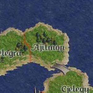
Ajitmon is a rural county covering the eastern half of the Isle of Athol rested between the Sea of Four Cities and Atholian Mane. The western half of the Isle of Athol is the rural county of Melegra. On the southern edge of the region is a bridge leading to the rural county of Cjelegy on the Isle of the Twin Cities. Fishing plays an integral part in the economy of Ajitmon with five prominent fishing villages (Poltur, Kansik, Torumbra, Churon, and Koinu.) Most of the farming is done in three villages, Hurrin, Varios, and Dissotia. The Ajiti Forest dominates the region and is considered one of the best destinations for hunting. A trail has been carved through the Ajiti Forest allowing quick passage from Hurrin and Varios. A local tribe that calls themselves Sons of Agirus roam the plains between the Ajiti Forest and the forest of Melegra.
Districts of Ajitmon

1 - Poltur is a fishing village on the coast. A dirt road to Fwuvo, a village in the region of Melegra, runs through the district.
2 - Kansik is a fishing village on the coast. A dirt road connects Kansik to the neighboring fishing villages.
3 - Torumbra is a fishing village on the coast. A dirt road connects Torumbra to the neighboring villages.
4 - 2nd largest village in the county, Varios, seated near coast, it supports both fishing and farming.
5 - Ajiti Forest (East), stretches to the coast.
6 - A single trail through the forest Ajiti, hazardous but quickest way to and from Varios.
7 - Ajiti Forest (West) covers most of the region.
8 - Plains, home of a local tribe called the Sons of Agirus, who often attack travelers on the dirt road that passes through the district.
9 - Dissotia, 3rd largest village in the region, seated in the middle of farmlands near the Ajiti Forest.
10 - Western Farmlands of Hurrin.
11 - Hurrin, seat of viscount, largest village in the region.
12 - Eastern Farmlands of Hurrin.
13 - Churon, a fishing village at the center of the district's coast.
14 - Ajitmon Bridge as it is called by the locals, though on the other side of the bridge it is called the Cjelegy Bridge. Occasional fights between locals of the two regions break out over the proper name of the bridge.
15 - Koinu, a fishing village seated at the center of the district's coast. Further inland is a dirt road that connects Koinu to the village of Hurrin in the east and the region of Melegra to the west.
Religion
Currently the region of Ajitmon is under the influence of Heralds of Obeah and has a primitive temple of Heralds of Obeah.
This article is a stub or placeholder. The BattleMaster Wiki is a collaborative effort, and you can help expand it by adding to this article.