User:Sanguinius/Sunriel Empire/Map
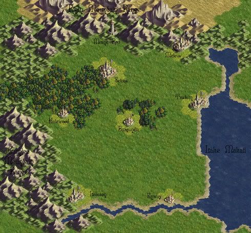
About the regional map... well for now it just has a geographical look of the region. The cities have all been named, as have been the two mountain ranges and the lake.
Though it is abit hard to read so. The whole northern mountain area is the Rigin Mountains. The mountains going along the bottom left are the Gamlec Mountains. The right side of the map is taken up by Lake Makaii. As for the actual cities present in the map, the one right in the center is Burgundia. To its north as part of the forest is Setras, and in the east next to the the lake is Tristam. These three cities, and the land in between make up the Kingdom of Setras. The bottom two cities are Lebason in the west and Enway in the east. And those two along with most of that plains area is the Grand Duchy of Lebason. The other city near the forest is Halewood, and makes up the Halewood Protectorate. Meleus is in the north east of the map, forming the Meleus Protectorate. So all together these realms would form the Federation known as the Sunriel Empire.
The only other place remaining on the map, is the tower in the center of the top. This is the fortress of Mesne Roc, which is also the name of that realm. It is not apart of the Sunriel Empire.
Before what was known as the Succession War, this entire region was called the Finngar Empire. Though sadly the ruler died, and quite a few of the Dukes decide to secede away from the old empire.
Now why can't this happen in the real game... it could really use alot more Dukes seceding from its mother realm. :P